
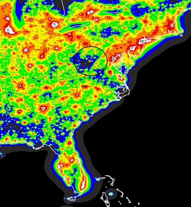
This light pollution map shows the amount of light pollution on the easter half of the united states. The darker areas on the map have less light pollution. As you can see Spruce Knobb State Park (SN) is in one of the darkest areas east of the Mississippi. It is a great place for observing. Another good location is Cherry Spring State Park (CS). The Black Forest Star Party is a very popular star party held at Cherry Springs State Park.
- High Light Pollution Areas: Major urban centers such as New York City, Washington D.C., Chicago, and Atlanta exhibit significant light pollution, resulting in highly illuminated skies and poor conditions for astronomical observation.
- Moderate Light Pollution Zones: Suburban areas and smaller cities show moderate light pollution. These regions have some visible stars, but light interference still affects night sky quality.
- Dark Sky Sites: The map identifies several locations with minimal light pollution, ideal for stargazing. Notable dark sky sites include:
- Cherry Springs State Park, Pennsylvania: Known for its exceptionally dark skies.
- Great Smoky Mountains National Park, Tennessee/North Carolina: Offers good conditions for stargazing, especially in more remote areas.
- Monongahela National Forest, West Virginia: Provides excellent night sky visibility due to its low population density and minimal artificial lighting.
- Transition Zones: Areas transitioning from urban to rural settings show a gradual decrease in light pollution, offering better conditions for observing celestial objects.
Overall, the map serves as a valuable tool for identifying regions with optimal dark skies and planning astronomical activities in the eastern United States.